How to Translate Map for International Travelers
- Part 1. How to Translate a Map for International Travelers
- Part 2. Why Translating Maps is Important
- Part 3. Steps for Translating a Map
- Part 4. Best Practices for Translating Maps
- Part 5. Challenges in Map Translation
- Part 6. Step-by-Step Guide: How to Translate Map with PDNob Image Translator
- Part 7. Conclusion
Maps are indispensable for helping travelers navigate new locations. However, if the map is in a language that the traveler cannot understand, its utility diminishes significantly. Translation ensures that these tools remain practical for everyone, regardless of language barriers.
Translating a map is not as simple as translating text; it involves careful consideration of geographic terms, place names, street names, and symbols. Additionally, geographical and cultural differences can make accurate translations more complex.
For instance, a local street name might carry cultural significance, and certain symbols used on maps might not have direct equivalents in other languages. Therefore, the translation process must be both precise and culturally sensitive.
In this guide, we’ll break down why translating maps is essential for international travel and how to ensure your map translations are accurate and effective.
Part 1. How to Translate a Map for International Travelers
In an increasingly globalized world, travel has become more accessible than ever. However, navigating unfamiliar territories can be a daunting task, especially for international travelers who are not fluent in the local language.
One of the most essential tools for travel is a map, but maps are often designed with local language, symbols, and conventions that might not be immediately understandable to non-native speakers.
Translating maps is not just a convenience—it’s crucial for ensuring easy navigation and improving the overall travel experience.
Part 2. Why Translating Maps is Important
Helping International Travelers Navigate Unfamiliar Locations
Maps are often the primary tool for tourists and travelers navigating unfamiliar areas. However, if the map contains language or symbols that the user doesn’t understand, it becomes much less effective. Whether it's a city map or a larger geographic map of a region, translating essential elements such as street names, landmarks, transportation routes, and points of interest allows international travelers to make better use of the map.
Without these translations, travelers could find themselves lost, confused, or unable to enjoy the full range of services and attractions available in a new location.
Enhancing Tourism and Accessibility in Non-Native Regions
For tourism businesses, offering maps in multiple languages can significantly enhance accessibility for international visitors. Whether you're a hotel owner, a travel agency, or a local government agency, providing a translated map to visitors can increase tourism satisfaction and engagement.
Translated maps help travelers feel more comfortable and confident while exploring a new area, which leads to higher tourist satisfaction and potentially more visitors in the future.
By translating maps, you also promote inclusivity, ensuring that individuals from different linguistic backgrounds can access the same resources and enjoy similar experiences in foreign regions.
Part 3. Steps for Translating a Map
Translating a map is a multi-step process that requires both linguistic expertise and design skills. Here are the essential steps to follow to ensure your map translation is accurate, useful, and aesthetically pleasing.
Step 1: Identify Key Areas for Translation
The first step in translating a map is identifying the critical areas that need translation. Start by reviewing the content of the map and determining which elements are most important for the user. These elements typically include:
- Landmarks: Famous buildings, parks, historical sites, and natural features should be translated accurately to ensure travelers can find them.
- Street Names: Local streets and neighborhoods need to be translated so that travelers can navigate by them.
- Transportation Routes: Train lines, bus routes, and metro stations are essential for public transit users. Ensure that route names and station names are translated properly.
- Points of Interest: Translate restaurants, hotels, tourist attractions, and other important places that may be listed on the map.
Ensure that you prioritize high-traffic areas or locations that travelers are most likely to need while navigating.
Step 2: Use Translation Tools
Once you’ve identified the key elements to translate, it’s time to leverage technology to simplify the process. Manual translation can be cumbersome and error-prone, especially for large maps with many elements. This is where automated translation tools, such as PDNob AI Image Translator, can be incredibly helpful.
PDNob Image Translator allows you to upload a scanned image of a map and extracts the text using Optical Character Recognition (OCR) technology. The tool then automatically translates the text into the desired language. This step removes the need for manual translation and helps ensure that all text on the map is captured and translated accurately, saving you time and effort.
Additionally, PDNob Image Translator supports multiple languages, making it ideal for translating maps that cater to a global audience. By using this tool, you can translate a map in a fraction of the time it would take to do so manually.
Step 3: Layout Considerations
After extracting and translating the text, it’s essential to adjust the map’s layout to accommodate the translated content. Different languages often require different amounts of space.
For example, a translation in German may take up more space than the original text in English, whereas languages like Chinese may require less space.
- Font Size and Style: The translated text should be legible but should also fit within the existing space on the map. You may need to adjust font sizes or the layout of the map itself to ensure all translated text fits properly.
- Map Design Elements: Certain languages may require different reading directions (e.g., right-to-left languages like Arabic or Hebrew). Make sure the layout accounts for this if your map will be used in regions with such language conventions.
- Color and Symbols: Be mindful of any color or symbol adjustments needed. Some symbols might not be universally understood, so consider replacing or explaining them if necessary.
Part 4. Best Practices for Translating Maps
To ensure the best possible translation, consider the following best practices:
Ensure All Names are Translated Correctly
Place names, street names, and landmarks are essential to map navigation. Incorrect translations can lead to confusion or misdirection, so make sure these names are translated accurately and appropriately. Avoid literal translations that may not make sense in the target language. Instead, rely on widely accepted translations or the official names of locations when available.
Be Mindful of Space Limitations
Maps are typically compact, so space is at a premium. When translating text, be mindful of the space available for each element. Overcrowding the map with text can make it difficult for travelers to read and use effectively. Try to keep translations concise without losing the essential details.
Maintain the Map’s Overall Layout Integrity
While translating the text, ensure that the map’s layout remains consistent and that its design remains clear and effective. The map should not only be translated correctly but also retain its visual appeal and navigational clarity. This will allow users to easily interpret the map’s contents, regardless of the language.
Part 5. Challenges in Map Translation
Translating a map is not without its challenges. Some of the most common challenges include:
Difficulty in Translating Place Names and Geographical Terms
Place names are often deeply tied to the local culture and history, making them challenging to translate. Additionally, some place names may not have direct equivalents in other languages. This is particularly true for historical landmarks or cities that may be known by different names in different languages.
Geographical terms, such as mountain ranges, rivers, and other natural features, may also be difficult to translate, as they may not have a universal designation. In these cases, it's important to research local names and ensure that the translation respects cultural significance.
Adapting Symbols and Measurements
Different regions may use different symbols to represent certain features on a map (e.g., different symbols for a park, hospital, or shopping mall). These symbols may not always have direct counterparts in other languages. Additionally, measurement systems (metric vs. imperial) and currency symbols may need to be adjusted based on the target market.
It’s essential to adapt these elements carefully to avoid confusion and ensure that the map remains easy to interpret for travelers.
Part 6. Step-by-Step Guide: How to Translate a Map with PDNob Image Translator
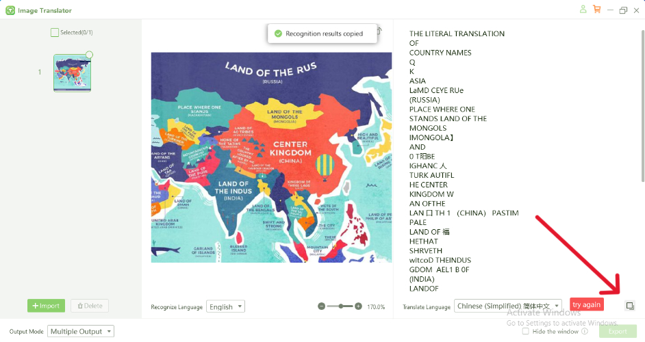
Follow these steps to use PDNob Free AI Image Translator for translating a map efficiently:
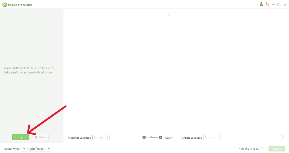
- Download the Software from Official Website
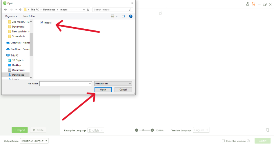
- Upload the Map Image
- Select the Image you want to Translate
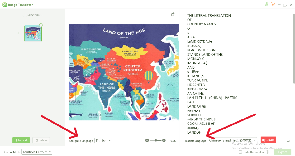
- Choose the Language for Translation
- Translate and Copy the Text
Part 7. Conclusion
Translating a map is a key component of making travel more accessible for international visitors. It ensures that travelers can navigate unfamiliar regions with ease, ultimately enhancing their experience and promoting tourism in non-native areas.
By following best practices and leveraging powerful tools like PDNob Free AI Image Translator, businesses and governments can provide accurate, culturally sensitive maps that cater to a diverse audience.
With the right translation tools, the process of translating maps becomes faster, more accurate, and more cost-effective, ensuring that international travelers have the resources they need to explore new places with confidence.
Speak Your Mind
Leave a Comment
Create your review for Tenorshare articles
 PDNob Image Translator
Instantly translate various types of images to text.


